Nekima Levy Armstrong, center, a local civil rights lawyer, is a lead defendant in the Justice Department’s case against a group of activists and journalists who were arrested over a demonstration at a St. Paul, Minn., church.


|
Pragmatic idealist. Worked on Ubuntu Phone. Inkscape co-founder. Probably human.
|

While recycling is a mathematically obvious response to the finite, non-renewable nature of many resources, the economic math is often challenging. For many materials, it can be hard to compete with virgin materials on a cost basis. Fast-moving technologies like electric vehicles throw in an added complication: By the time a car is scrapped, the industry may have moved on to a different battery chemistry. That reduces the value of recycling the car’s battery back into the production chain.
Still, a study led by Xin Xiong at Nanjing University finds that in China, recycling could become the dominant source of many key materials needed to manufacture EV components over the coming decades.
The researchers set out to model how the supply of recycled materials compares to manufacturing demand in China between 2010 and 2050. It covers materials relevant to batteries across hybrid, battery-electric, and even fuel-cell vehicles (lithium, cobalt, nickel, manganese, phosphorus, sodium, sulfur, and graphite), as well as several critical elements used in electric motors (copper, neodymium, dysprosium, samarium, and cerium).
The researchers considered four scenarios for technological progression. Some see battery and motor chemistry slowly transition to technologies like solid-state lithium, sodium batteries, or motors with reduced rare-earth content. Other scenarios transition more quickly. The model calculates the “circularity potential” of each element over time—how much of manufacturing demand can be supplied by the flow of recycled material in that same year.
It also factors in recent Chinese policies, which aim to increase recycling rates of certain battery elements from the current 40 percent to a new standard of at least 98 percent, and to increase the share of EVs in new sales from 45 percent to 60 percent by 2030.
Though hybrid and plug-in hybrid vehicles eventually fade out, the sales of battery electric vehicles continued to increase all the way to 2050 in their model. This leaves the number of vehicles hitting recyclers lagging behind but also steadily increasing. (The model assumes that battery replacement will be common, since batteries can lose capacity long before a vehicle hits end-of-life, primarily in commercial settings with heavy use. Between that and China’s battery-swapping stations, this means extra batteries being manufactured and recycled.)
Nevertheless, the amount of manufacturing demand that can be met by recycling generally rises to pretty high levels across all scenarios, though the patterns look a little different. Early on, the supply of recycled materials rises as the growth of EVs eventually drives a corresponding growth in dead EVs.
But for some elements like cobalt, demand can drop as the industry pivots to low-cobalt battery chemistries—and the recycled supply quickly exceeds demand. Conversely, the amount of nickel and manganese needed for batteries could increase drastically over time, keeping the share that recycling can supply pretty flat.
The story for elements in motors is similar, but it's also quite sensitive to the nature of the technological change—like if cerium is used to displace more expensive rare-earth elements, for example.
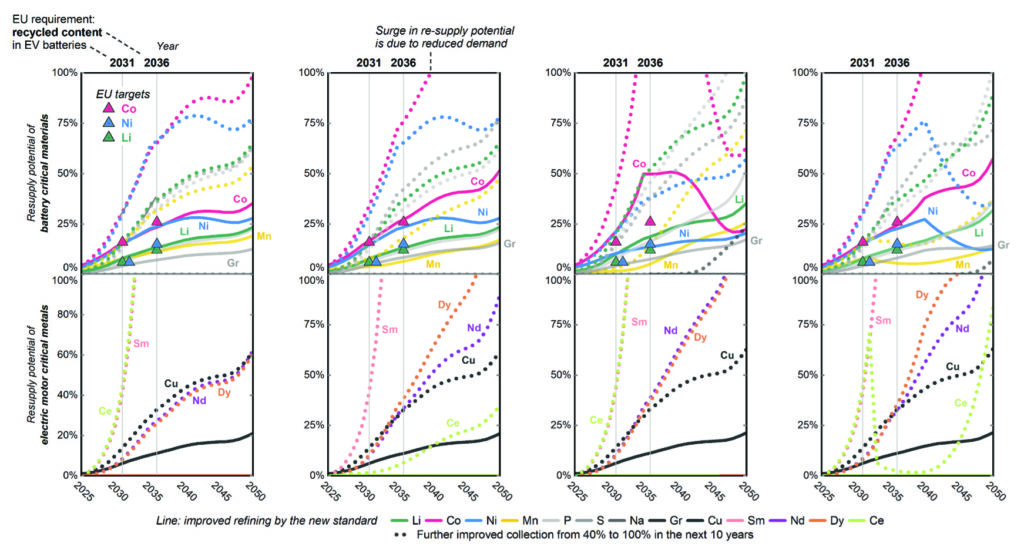 Amount of manufacturing demand supplied by recycling for four scenarios: slow technological change (left), faster change, a complete transition to new chemistries, and a progression through those first three scenarios decade-by-decade (right). Solid lines are with 40 percent of vehicles recycled, and dotted lines are with 100 percent of vehicles recycled.
Credit:
Xiong, et al./Joule
Amount of manufacturing demand supplied by recycling for four scenarios: slow technological change (left), faster change, a complete transition to new chemistries, and a progression through those first three scenarios decade-by-decade (right). Solid lines are with 40 percent of vehicles recycled, and dotted lines are with 100 percent of vehicles recycled.
Credit:
Xiong, et al./Joule
Depending on which scenario you find most plausible and which promising technologies you think will take over, this model can show you which demands can be met by effective recycling and which we’ll remain dependent on mining to supply.
This all hinges on the word "effective" in "effective recycling." The researchers highlight a number of links in the recycling chain that will need to be strengthened to reach the high end of their numbers.
China is using regulations to address a couple of issues, mandating “battery passports” that identify each battery and its chemical makeup and working to force more scrapped batteries to be sent to officially licensed recyclers. But the researchers also note that China has yet to mandate some level of recycled content in new battery production. And they say the complex recycling chain will be vulnerable to bottlenecks as it rapidly scales up to handle more electric vehicles over time.
Just as the graphite in batteries is often not recycled now because its value is low, the rise of technologies like sodium batteries could be a bit of a double-edged sword, too. Using a less expensive material makes batteries cheaper, but it also means their contents are less valuable to recyclers.
But although technological change complicates the goal of recycling EVs to build new ones, this model shows that the math could work out pretty well for many materials.
Joule, 2026. DOI: 10.1016/j.joule.2026.102602 (About DOIs).


Have you tried Chipotle’s new cilantro lime sauce? I’m a big fan. It’s creamy, super fresh and somewhat spicy. I’ve started ordering cilantro lime sauce in lieu of plain sour cream on my standard burrito bowl order, and it really takes my bowl to the next level.
I reverse-engineered this recipe from Chipotle’s ingredient list. It’s made with cilantro, lime, Mexican spices (I only add cumin), sour cream and roasted jalapeños. The only trick was getting the proportions right. I taste-tested my recipe and theirs side by side, and you know what? It’s hard to tell the difference, but I like mine better.
Chipotle is really the only “fast food” chain that we eat from, and I’m almost embarrassed to admit how often we order in. Maybe every other week? I love recreating their meal components so we can all make them from scratch when we have the time. This fresh sauce is a winner.
Continue to the recipe...The post Cilantro Lime Sauce appeared first on Cookie and Kate.
The Kansas City Chiefs were taking on the New England Patriots on September 29, 2014, when, with just eight seconds to go in the first quarter, the volume of the crowd’s roar reached 142.2 decibels. That’s about as loud as a jet engine taking off, and good enough to break the Guinness World Record for loudest crowd roar at a sports stadium.
A new Chiefs stadium might help them break it again.

The Chiefs previously set the record for loudest crowd in 2013 at 137.5 decibels, which was broken later that year when the crowd at Seattle’s CenturyLink Field reached 137.6 decibels. But since 2014’s game, when the Chiefs handed out earplugs to fans beforehand, the record has remained untouched.
When the team’s planned $3 billion stadium opens in 2031, though, that record could be at risk again. The lead architectural firm behind the stadium says it is designed to be as loud as possible by containing the sound through the actual size, shape, and roof geometry of the venue.

“We carefully designed the layout of the seating environment, the roof, and the concourse areas to contain the sound inside the seating environment, much more than the existing Arrowhead stadium does today,” David Manica, owner of Manica Architecture, tells Fast Company.
Manica, the Kansas City-based firm behind venues like Allegiant Stadium in Las Vegas and the Oklahoma City Arena in Oklahoma City, designed the stadium, and HNTB, another Kansas City firm, is the lead design architect.
The team says the stadium was designed to prioritize fan experiences like tailgating, with parking lot infrastructure big enough to hold more than 20,000 parking spots, and the pre-game flyover, by using 400,000 square feet of translucent panels for a clear view through its fully enclosed roof. When it comes to maxing out the volume inside the stadium, the entire venue’s shape was optimized for loudness.
The biggest challenges revolve around the density of the crowd and their proximity to one another.
“The secret to making a stadium loud is its ability to contain the sound energy within the volume,” Manica says, so they designed the new stadium with as few interruptions in the seating sections as possible. All spectators are as close to the field and to each other as possible.
The more compact the venue, the more concentrated the noise. The new stadium removed exit passageways in the bowl, while seating was designed to be as dense with people as possible, with continuous seating tiers and fewer internal aisles. The new stadium is expected to seat about 70,000 people, fewer than Arrowhead Stadium’s maximum capacity of more than 76,000. The roof shape, which is parabolic, makes sound louder because the shape directs sound waves back down toward fans.
Acoustic engineers digitally tested and analyzed the new stadium design, Manica says, and their analysis found that a crowd of a certain volume in the existing stadium “will actually be perceived as louder in the new building.”
“The new stadium will be even louder than the existing record-breaking Arrowhead,” he says.
When the Jumbotrons at the new Chiefs stadium say, “let’s get loud,” they’ll really mean it.

War memorials on the National Mall commemorate those who fought in one conflict at a time. A new temporary memorial that’s gone up on the steps of the Lincoln Memorial covers all of them.
The National Military Monument, an installation from the financial services company USAA for military members and spouses, is dedicated to all of the more than 41 million Americans who’ve fought in every war from the Revolutionary War to the conflicts of the 21st century. USAA installed the work to mark the 250th anniversary of America’s founding, and it was designed to mix the look of traditional monuments with cutting-edge tech.

The memorial is made up of two double-sided structures designed to look like fluttering U.S. flags. Each is positioned on either side of the steps leading up to the Lincoln Memorial. Each section is 18 feet tall and 62 feet wide, and the blocks used to make it were painted to resemble Indiana limestone, the stone used to build the Lincoln Memorial walls and columns.

Embedded in the structure are 528 LED screens that act like the stripes on the flag, and they display the names of U.S. service members, with each name separated by stars. It was designed by Atomic Designs, an event production company that’s designed staging for events like Jingle Ball and World’s Strongest Man.

With no single historical record of every American who’s served in the armed forces, USAA compiled its own list of veterans from sources including the National Parks Service, WWII Army Enlistment, POW lists, veteran service organizations, and USAA members who opted in.

There are currently nearly 41 million names being displayed. George Washington was the first name displayed for its public opening on July 28, and the Unknown Soldier will be the last. “John Smith” is the most common name in the installation, appearing 4,487 times.

It’s a living memorial. There’s an online portal and kiosks at the installation people can use to search for loved ones and submit the names of those who aren’t included. It can display as many as 2.54 million names a day for 45 seconds each, which means it would take about 16 days to go through every name.
A permanent memorial with as many names wouldn’t fit as neatly on the National Mall. By mixing the look of traditional monuments with video screens and public participation, though, the National Military Monument shows that it doesn’t take a permanent monument set in stone to make a big impact.
